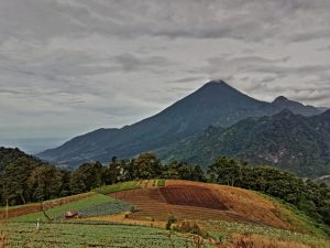
Surprise! Central America isn’t all low, flat, hot, humid and jungly! Until we came here, we never really thought of it as having a ‘highlands’, but blow me down with a feather… it does! Some parts are well over 2,000m amsl and it’s a fabulous climate up there: warm, sunny days and cool clear nights. It’s one of the reasons we’ve lingered so long in these places. Most tourists in Guatemala take in some highlands, maybe Guatemala City, definitely Antigua and Lake Atitlan. Fewer visitors explore the more remote Guatemala highlands. One reason is possibly because the media-machine of touristic publicity for these parts has yet to reach, shall we say… peak efficiency. Another reason is that the high roads are often just downright dreadful.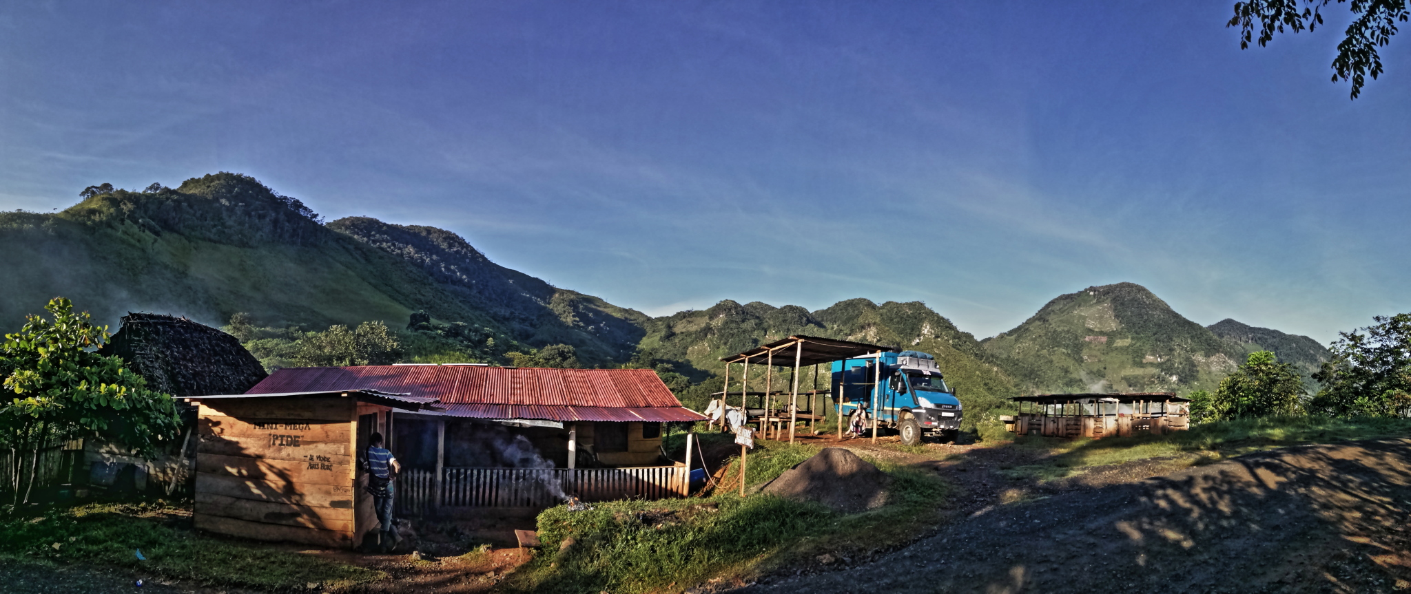
Highland Menu
Rolling back the clock a few weeks… we’d been in Guatemala for five or six weeks. We’d explored the customary hot-spots of the south-east and Antigua (btw… really loved it there, can absolutely see why it’s so popular with tourists and expats) and we’d put our new team-mate Mr Boaty McBoatface through his paces on the spectacular Lake Atitlan. Then we realised we were running a bit short on visa time. So we then had to hang around in Antigua a bit longer (oh, the hardship 😊) to extend our own permits as well as Cuthbert’s. Eventually, permit-mission accomplished, we could head out to explore the back and beyond.
So what did we find? What we found was loads to do. We could write a magnum opus about it all, but we’ll spare you the minutiae. Instead we’ll bore you with a little a la carte, taster-menu of highlights…
-
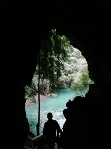
- View from a bat-cave
-
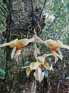
- Orchidacious
-
- The highest in Central America
- hiking to the volcano crater lake of Chicabal
- soaking in the Georginas natural hot springs
- watching glass-blowing at the Canter community factory (no ‘elf ‘n safety here, we were left to wander freely around the workshop, amongst the furnaces and red-hot blobs of molten glass being waved around as they’re formed into bottle-shapes)
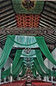
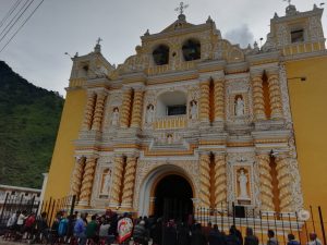
- wandering many cutesie villages of rural communities with fabulously painted churches (like San Andres Xecul and Todos Santos)
- seeing coffins being hand-made in a workshop (yes, this is a thriving staple-industry in a few villages)
- learning about the curious world of orchids in Cobán (not as dull as you might think, honest!)
-
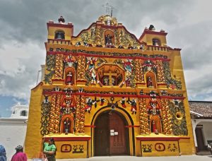
- Bright churche
-
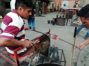
- Hot glass
-
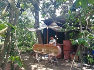
- A happy soul… making coffins
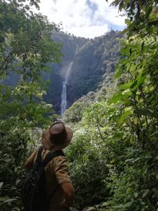
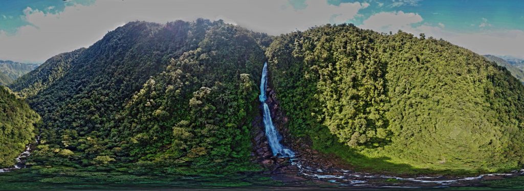
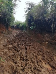
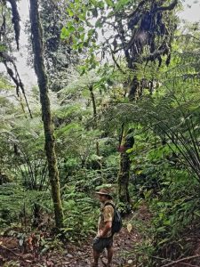
- doing a very muddy hike in Chilascó to the highest waterfall in Central America (at least Guatemala claims it’s the highest, and who are we to argue?)
- tubing down underground rivers dodging the stalagmites and stalactites of Candelaria; watched thousands of bats fly to sunset out of a huge cave-mouth at Lanquin
- seeing how old US school buses are driven down via Mexico and converted for use as local ‘chicken buses’ to run between the villages
- gulping at (yet more!) venting volcanos (Fuego and Santiaguito are popping-off several times a day!)
- hearing stories about the 1970s civil war and the inspiration the revolutionaries gained from Che Guevara’s earlier antics in South America
- having cleaner-fish feast on our feet in the river (eeuugh!!)
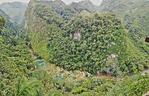
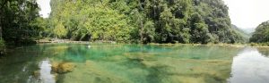
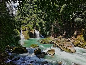
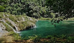
- marvelling at the pristine multi-tiered aquamarine pools of Semuc Champey……
-
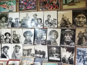
- Faces of the War
-
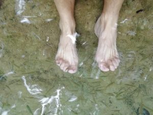
- Cleaner-fish eating us alive
-
- Always venting
Now if that’s not an eclectic range of activities, I don’t know what is! Between all that, on 1st September Cuthbert reached his 160,000 km milestone, so Marcus fitted in the routine servicing.
Highland Culture
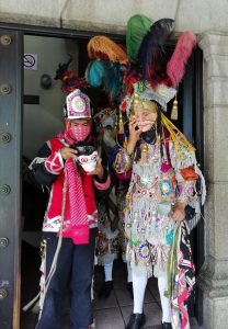
Then there’s the highlands culture-thing too. It’s impossible to tour the Guatemala highlands and not be struck by the distinct regional cultural identities. The majority of the population are indigenous Mayas and they have some wonderful customs and celebrations. Ancient traditions live-on strong in Maya communities. In some areas they speak very little Spanish. There are apparently 23 different and distinct regional Maya languages, but it’s not just the languages that differentiate the cultural identities – the clothing is quite different too.
-
- Maya Party outfits
-
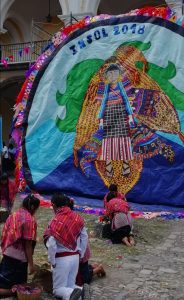
- Maya Worship
-
- Groovy clothes
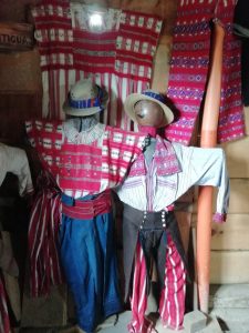
Each area, in fact almost each individual village, has a distinctive costume. Women, including little girls and teenagers, wear the colourful local huipiles almost to the exclusion of any kind of ‘western’ clothing. Colours, patterns and styles vary from village to village, so each lady designs and embroiders her own clothes within the style of her village’s tradition. We found only one region (around Todos Santos) where men comply with the traditional norm: red and white striped trousers, jackets with large, beautifully embroidered collars and woven straw hats. Tradition has it that a woman is judged by the quality of her husband’s attire. The finer his embroidery, the finer the wife. I guess it says something for equality in most of Guatemala that men now wear shop-bought western-style clothing!
We’ll take the high-road
So we loved the Guatemala highlands, but we couldn’t stay up there for ever. After winding around many back-roads, we realised that if we want to finish exploring Guatemala and reach Belize, we will at some point have to descend to the heat ☹.
Our last highland destination is the natural aquamarine pools and falls of Semuc Champey. From there we take one of the many bad, rural tracks and head east towards Lake Izabal in the low ground. For reasons which become bleedin’ obvious when you drive them, these rough mountain routes aren’t much frequented by tourists, or even many other overland travellers. It’s not necessarily off-road/4×4 territory, but the boulders and deep ruts would be a struggle without high-clearance. Around here all the locals have high-clearance backie-trucks – even they wouldn’t attempt these routes in the hideously clapped-out Toyota Corollas that navigate the cities!
-
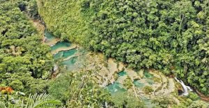
- In Semuc Champey – don’t you just want to swim in those pools? 🙂
-
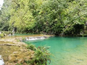
- Semuc Champey – Like fake news… but not!
-
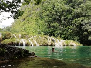
- Semuc Champey – Swimming in those pools!
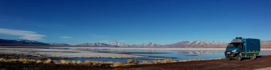
Now we don’t mean to brag… but our Cuthbert is a particularly awesome little truck for these rough, high roads. Of course, we’ve known this for a while 😉, but these routes have reinforced our rather biased opinion in this respect. How can we be so sure? Well… we have an App on our phones called iOverlander. For the uninitiated, it’s a mapping app on which overland travellers add map-dots to show great camping spots, favourite restaurants, or warnings about things like difficult or unpassable roads.
As we’ve alluded to… some of the Guatemala highlands roads are pretty rough. These generate several ‘bad road’ warnings on the iOverlander map, such as “terrible road…”, “don’t take this road…” or our all-time favourite: “big-rigs won’t make it”. Sounds helpful to know this stuff, but here’s the thing: we find that comments with specific warnings for big-rigs (and by big-rigs we mean camper-trucks in the 8,000-12,000kg range, far larger than Cuthbert) are often penned by people who don’t themselves actually drive a big-rig. Those who do drive big-rigs are generally, extremely capable at manoeuvring their rigs through challenging road conditions. Even with our mere 5,900kg, overlanders with smaller vehicles often underestimate conditions that trucks like Cuthbert can handle.
In our experience, these ‘big-rig warning’ roads are rarely as challenging as described. On a stretch of bad highroad from Semuc Champey past Cahabón, warnings predict that a stretch of approx. 60km will take a vehicle-bashing six to ten hours. Cuthbert did it comfortably, stress-free, in just five hours. He didn’t even break into a sweat 😊. Our 12kph average isn’t going to win any land-speed records, but it shows what an awesome little star our Cuthbert is for travelling all conditions. As you can tell… we’re rather proud of him!
Maya Hospitality
On the steep hillsides of this route we struggled to find a level park-up spot for the night. All the roadside pull-offs we could find were either steep, or uneven, or both. A lovely Maya family kindly offered us the opportunity to share a flat spot in their garden. A typical example of warm, generous hospitality of the Maya people. It was our last night in the beautiful, cool highlands for a while, so we savoured our last night up there and had an interesting time with the friendly family.
The highest in Central America (allegedly)
Only the father spoke Spanish and he went out of his way to make us welcome, telling us about the family and their lifestyle in the mountains. He absolutely refused to accept any kind of payment for us using his land, so in the morning I approached his little shack-stall at the side of the road. I figured I would be able to give him some business and buy a few items to add to our store cupboard.
When I looked at the shelves, his total stock consisted of packets of powdered dried bean (a Guatemalan staple – mixed with water to make a thick bean paste, rather unappetising) and a few cans of day-glo-orange, sweet, sticky, local-brand fizzy drinks. These are almost as unappetising as the bean-paste-powder, but by the smallest of margins the drinks win the day. I relieve him of his last few cans, assuring him that we will enjoy drinking them later on the road.
Next day, we finished the highland route and descended to the low ground with mixed feelings. Relieved to reach smoother roads, dismayed to feel the heat, but excited to see what we’ll find in the humid lowlands and Caribbean coast of Guatemala. That’s a story for the next instalment, coming to a device near you… soon!
Guatemala Highlands – Photo Gallery
-
- Semuc Champey
-
- The highest in Central America
-
- Semuc Champey
-
- Muddy hike
-
- In Semuc Champey – don’t you just want to swim in those pools? 🙂
-
- Semuc Champey
-
- Cleaner-fish eating us alive
-
- Semuc Champey – Swimming in those pools!
-
- Semuc Champey
-
- Semuc Champey – Like fake news… but not!
-
- Elaborate
-
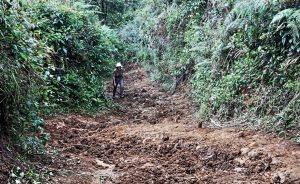
- Muddy hike
-
- View from a bat-cave
-
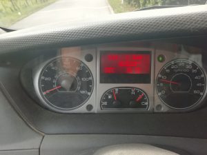
- Cuthbert’s 160,000km
-
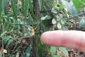
- Teeny orchid
-
- Orchidacious
-
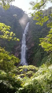
- It’s high, but is it the highest?
-
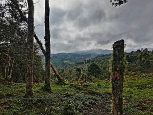
- Guatemala highlands
-
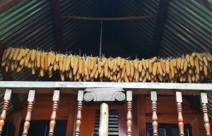
- Drying maize
-
- Faces of the War
-
- Groovy clothes
-
- Bright churche
-
- Hot glass
-
- Always venting
-
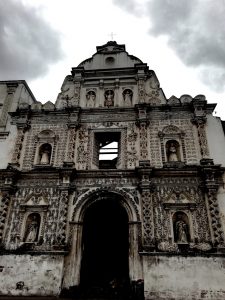
- Not-so-bright church
-
- Yellow’s popular
-
- A happy soul… making coffins
-
- Maya Party outfits
-
- Indiana Tuck
-
- Maya Worship